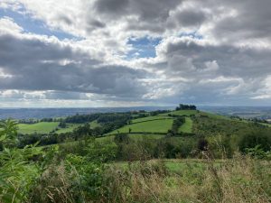
A mostly flat figure of eight high on the Cotswold plateau, which can easily be shortened to one loop. Striking views over Bristol can be found along the route as it passes through an Iron Age Camp on part of the Cotswold Way, as well as Bath and beyond views from Prospect Stile.
Download the pdf for the full description and map.
You can see a video of part of the walk here (the northern triangle section is wheel-friendly, but not yet the whole walk):
Start & Finish: Lansdown Park & Ride *W3W – harder.they.bother
Distance: 6.25 mile / 10 km with an up and down of 168 ft / 51 m
Slopes: Mostly flat with gentle undulations. One short steep slope on southern loop.
Steps & stiles: None
Terrain: Surfaced and unsurfaced paths.
Transport: Visit travelinesw.com. Lansdown Park & Ride served by buses and parking available for non-bus users for a small fee (online or app payments only)
Public toilets: Lansdown Park & Ride (20p)
Refreshments: The Charlcombe Inn, Lansdown Golf Club.
Rest points: Benches on northern most section.
Dogs welcome: Yes, though playing fields at the start, livestock often in fields and some roadside walking so please be prepared to put them on a lead.
Wheel friendly: Not all of it yet! But the northern triangle, between points 5 (Racecourse), 3 and 4 on the map are. This is the section featured in the video.
Features on the route: The Cotswold Way, Bath Racecourse, Prospect Stile view point.
Note this is an exposed walk on high ground so it can be cooler than elsewhere, an extra layer is recommended! We also recommend you check the Bath Racecourse website for upcoming race days and avoid visiting on those days. There is no racing through the winter months.
Please note – the version of this walk on our digital map slightly deviates from the pdf version. Walk 18 Lansdown on the Level to stay on the correct route which is better underfoot and slightly shorter.


